 I recently had the pleasure of browsing the 1936 edition of a most interesting children’s almanac or encyclopedia called the Gakuyū Nenkan (学友年鑑 School friend almanac). I’m most grateful to learn of the text thanks to Katy Hui-Wen Hung, co-author with Steven Crook of The Culinary History of Taipei.1 Katy had this colonial period book carefully scanned, which was once used by her father Dr Hung, Tsu-pei (洪祖培), born in 1926, when he was a student at the Kabayama (Huashan) elementary school (樺山小學校). The book, almost four hundred pages in length, is now up on archive.org and available here: 學友年鑑 1936. While I encourage you to explore the book yourself, especially if you can read Japanese, below I’ll give a bit of an overview of its contents. You can click on the images for a higher quality version.2
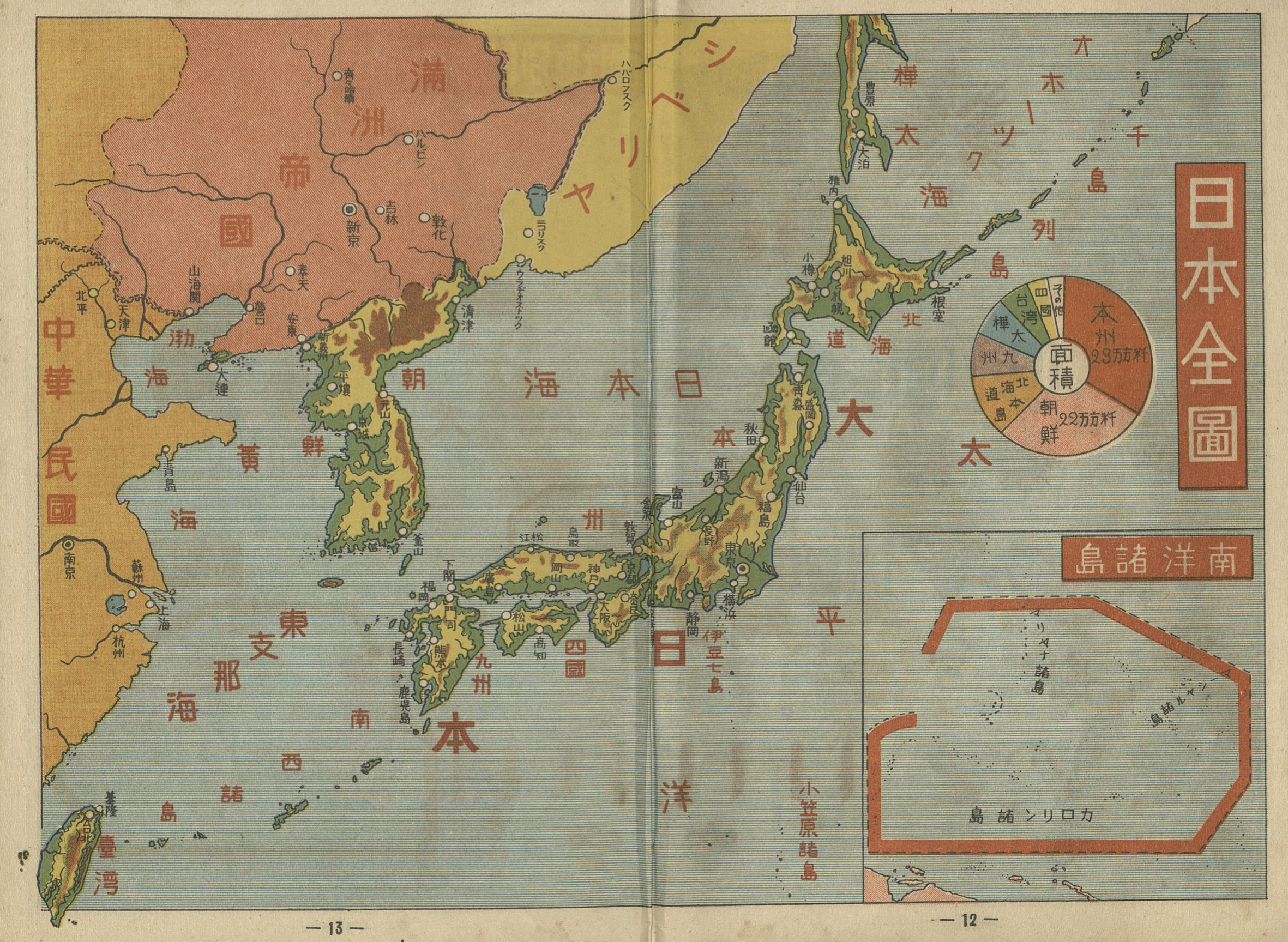
Early in the book, a map of Japan’s territories is presented along with a pie chart, offering the child a spatial overview of the relative size of Japan’s constituent parts. This edition of the book comes only a year before Japan’s full scale invasion of China and instead of dividing Japan into its home islands and then other colonial territories, areas are broken up into smaller units, with the Korean peninsula side by side with the largest land mass of Honshū island. Hokkaido, Taiwan, Karafuto (South Sakhalin), Shikoku, Kyūshū, and others are listed by size, but in one pie as a coherent whole, including Dairen/Dalian on the Liaodong peninsula. Naturally, being 1936, the nominally independent “Manchurian empire” is listed as well. Another feature we might note is that the former German possessions in the Pacific, the South Seas Mandate (listed here as 南洋諸島) is also part of this overall presentation of Japanese territories, despite the fact these islands were under a League of Nations Mandate. I would not be surprised if European empires did much the same in their maps.
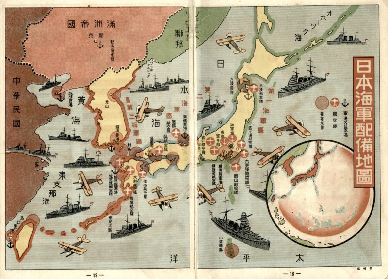
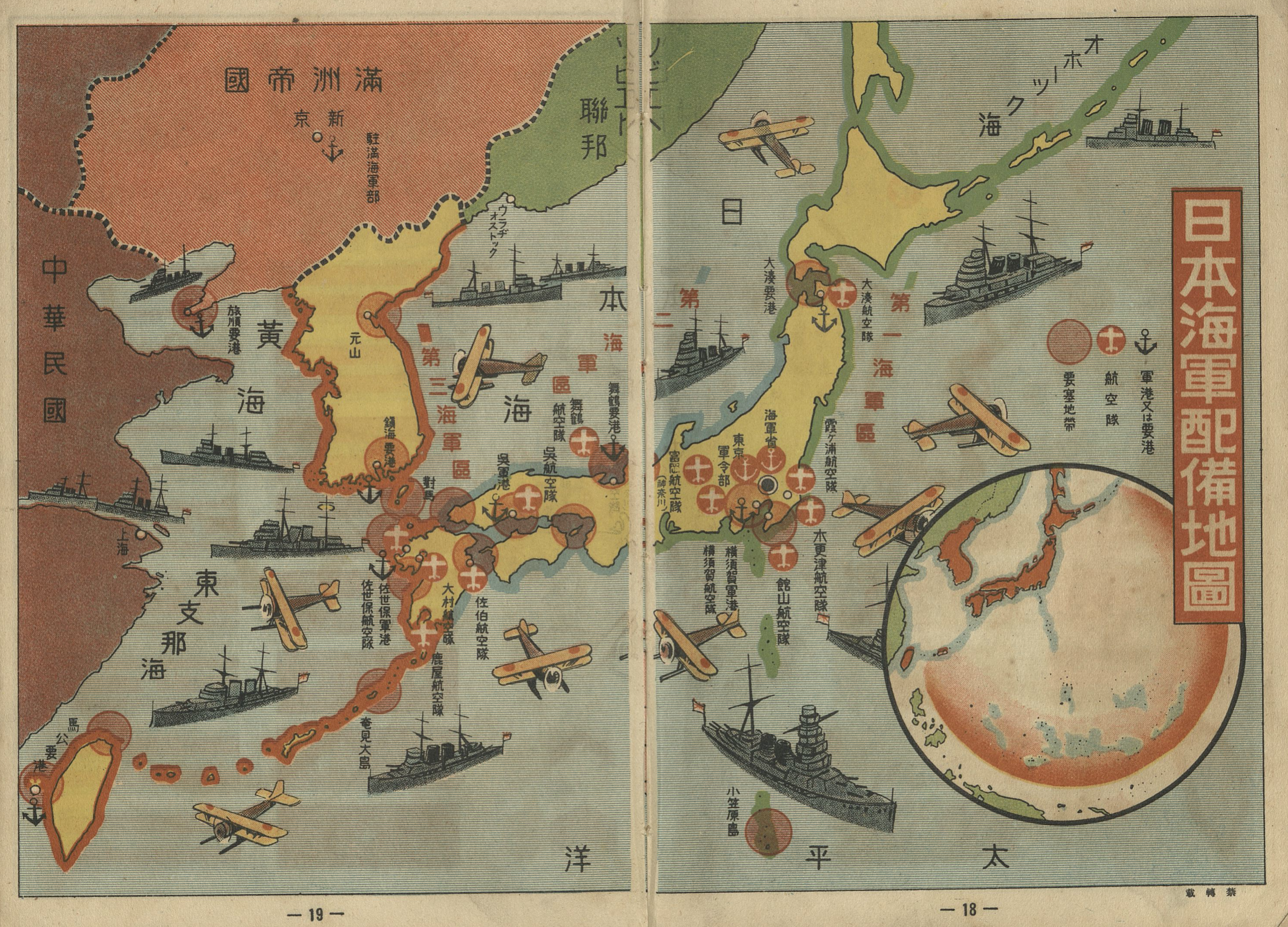
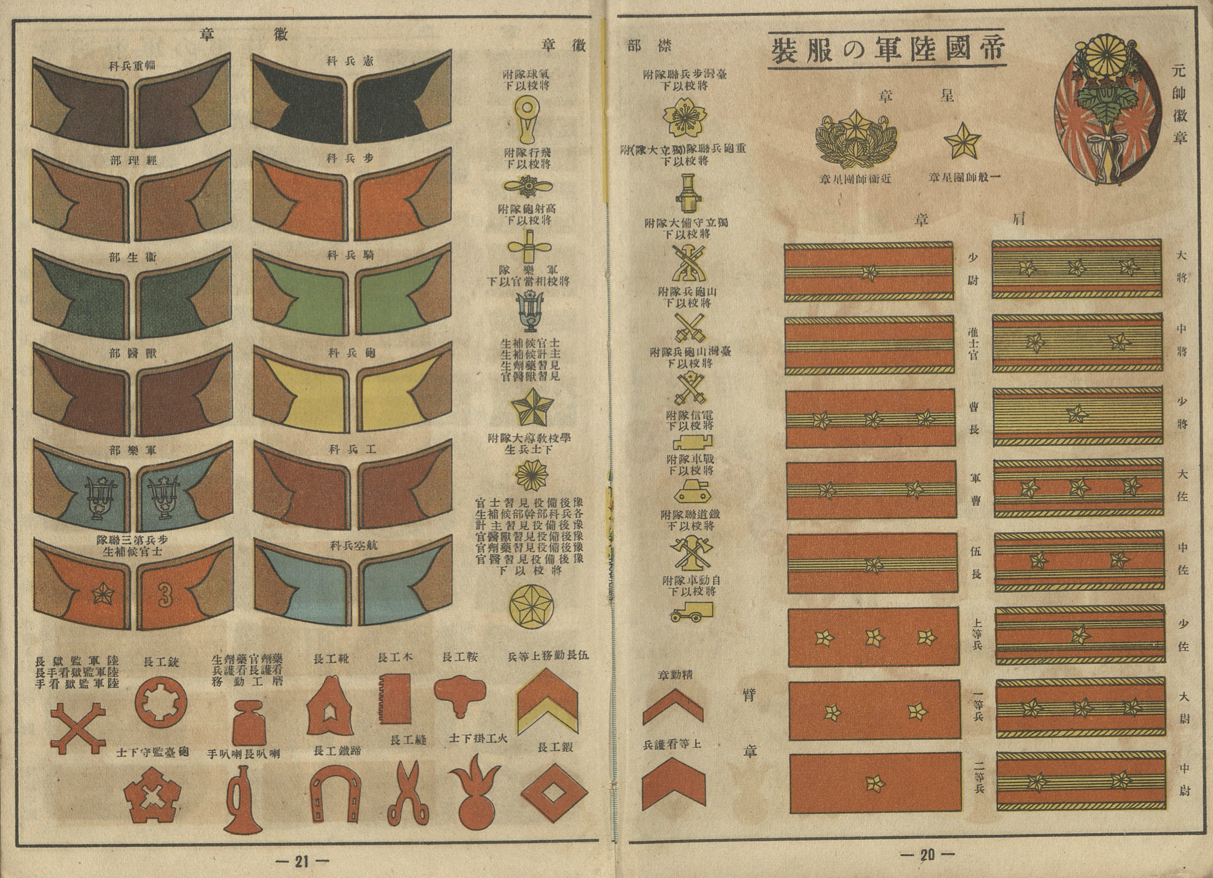
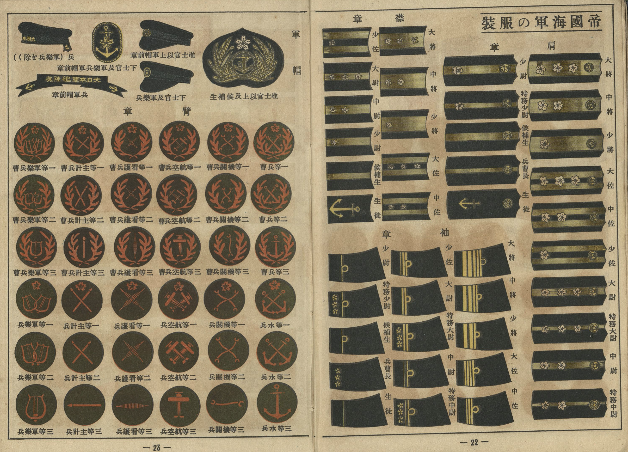
One of the things that is immediately noticeable is the militarist nature of the book. Flipping only a few pages into the content, past the opening Japanese and world maps, the child is presented immediately with the location of Japanese army and navy bases, followed by lists of military ranks and insignia.
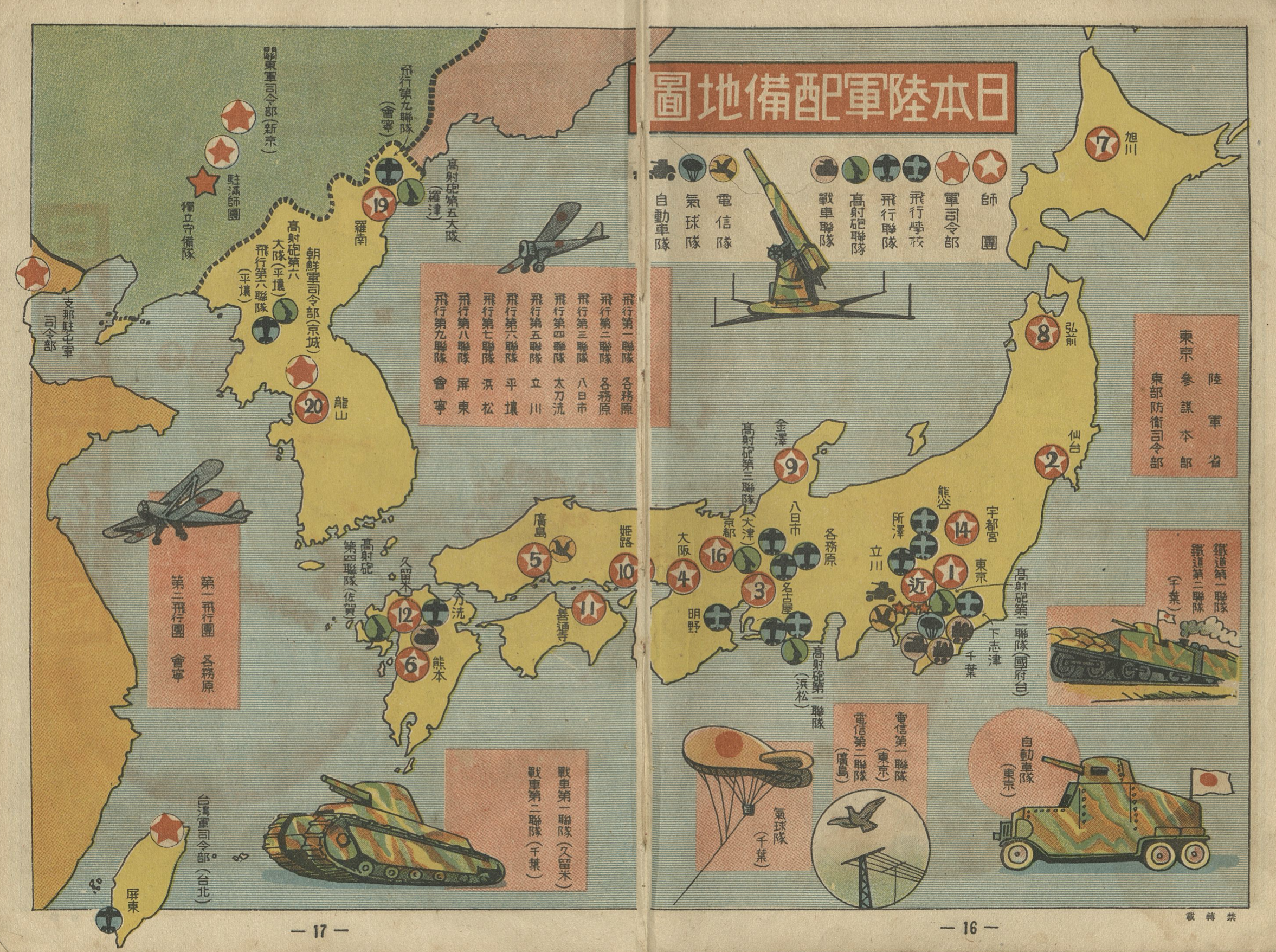
After introducing the child to the Japanese military on several pages, the book moves on to a comparison of military might, with a special inset in one corner with a comparison of naval forces between Japan, the United States, Britain, France, and Italy.
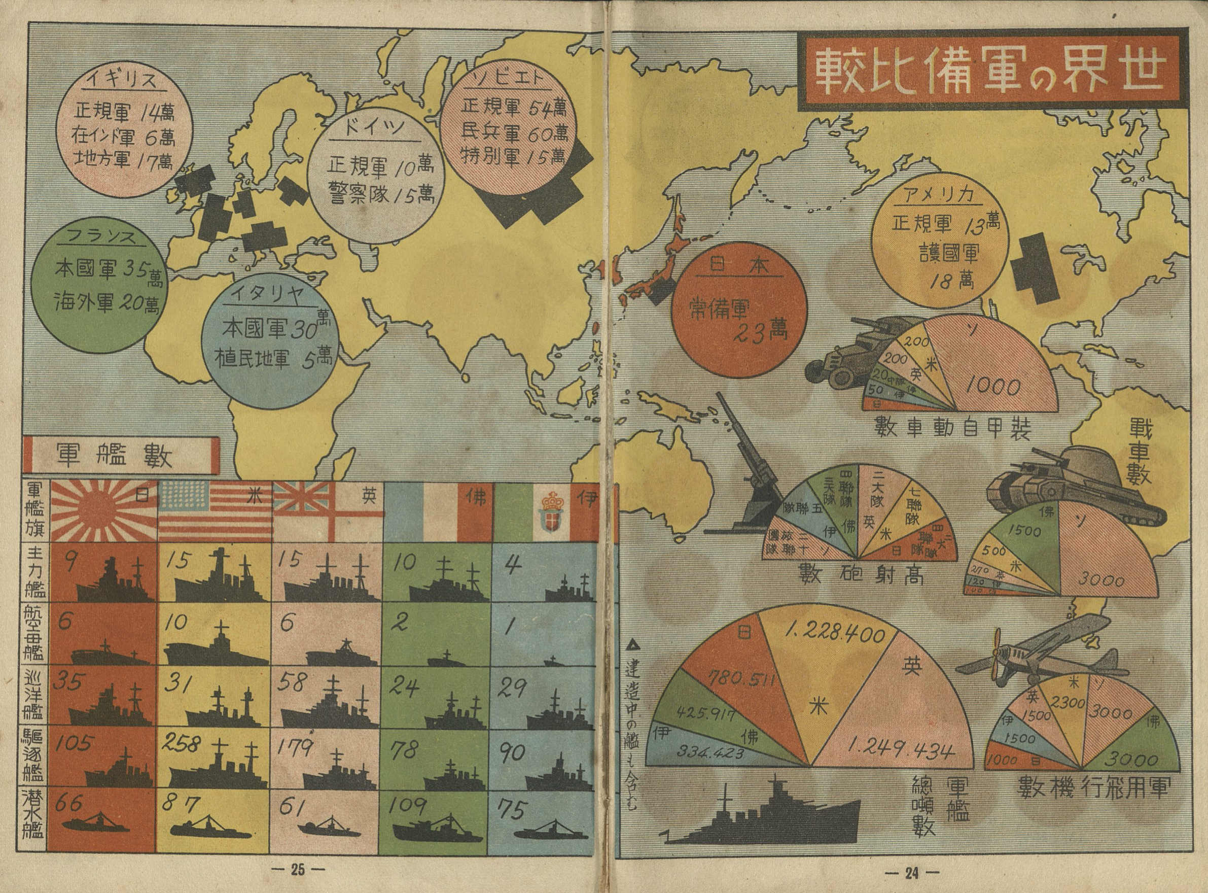
When it comes to raw soldier counts, a child looking at the numbers may think Japan, despite its small size, compares rather favorably to its potential rivals, with the exception of the Soviets with its over million troops facing ominously towards Japan. Interesting divisions are shown for different places. The British army is divided between regular army, regional army, and the Indian army. Italian and French forces distinguish with the army at home and “colonial” or “overseas” forces, respectively. German forces are divided between its regular army and “police units,” while the United States has numbers listed for regular army and its national guard.
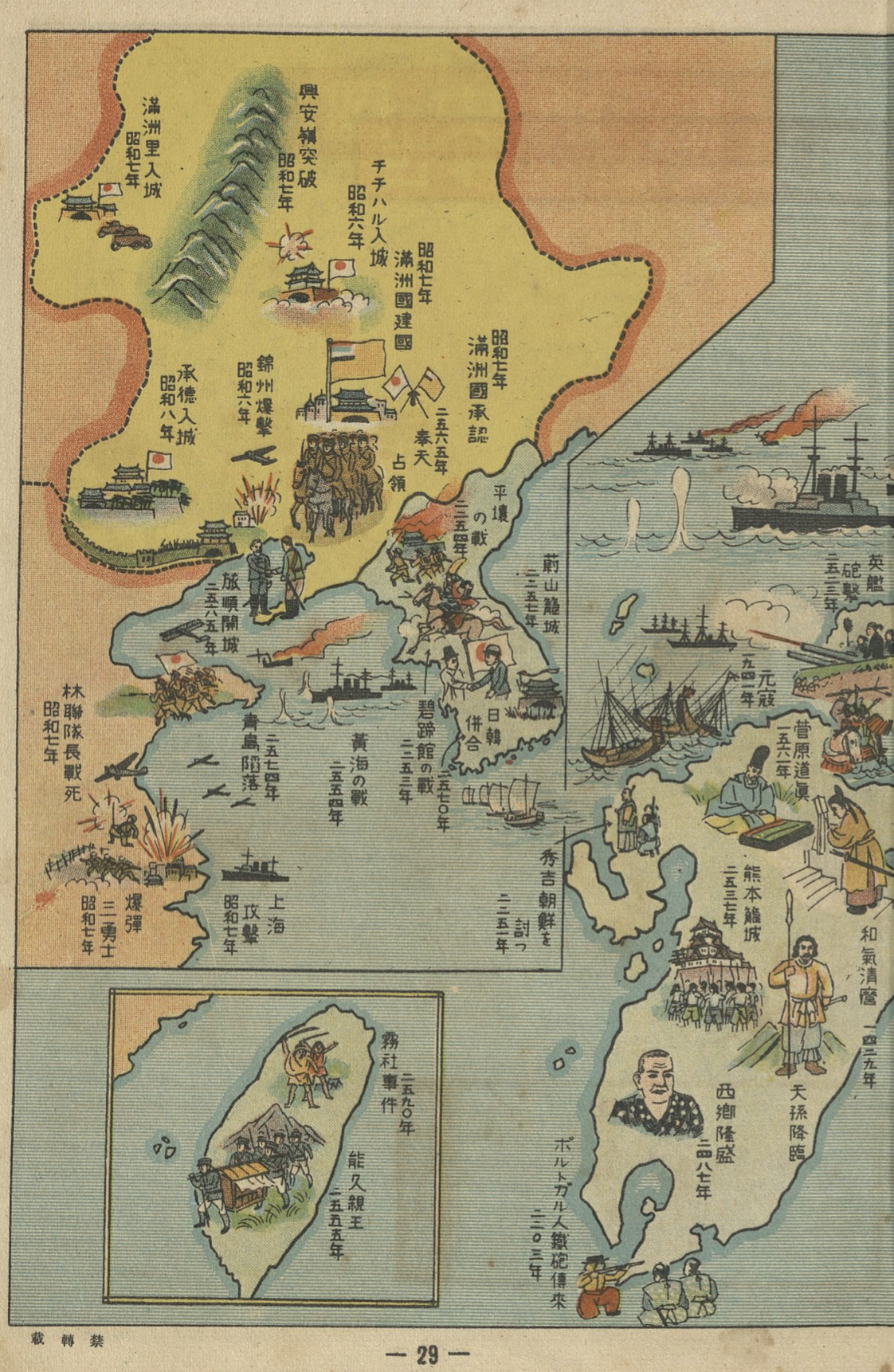
Maps which highlight important sites with small drawings of objects, people, or depictions of events, are found most often in tourist maps, but play an important role in educational texts as well. They are literally “writ large” on the map, and the large size of the scene relative to the scale of the map severely constrains the number of events a mapmaker might include. In historical maps like this, they thus offer us a particularly clear view of what was seen as important from the viewpoint of its author.
The events depicted inside of Japan’s home islands are iconic moments in Japanese national history, as we might expect. We might note, however the way that most of the events chosen for depiction outside of Japan proper similarly highlight moments of Japanese expansionist glory, including the depiction of a Japanese person in what looks like a bowler hat shaking hands amiably with a stereotyped Korean yangban (Year 2570/1910). Japanese soldiers fill the Shandong peninsula to represent the fall of Qingdao in the imperial year 2574 (1914) when Japan joined the Allies in World War I and swiftly moved to seize the German concession in China.
For Taiwan, only two events are given mention. There is a depiction of Prince Kitashirakawa Yoshihisa-shinnō (labeled Yoshihisa-shinnō 能久親王) whose major achievement was dying of malaria in Taiwan in 1895. Interestingly, the 1930 Wushe Rebellion / Musha Incident against Japanese oppression is mentioned, and two indigenous Tgdaya are depicted with their weapons held high. While the March 1 movement of 1919, so important in the colonial history of Korea is unsurprisingly not depicted on the Korean peninsula, the inclusion of the Musha incident on Taiwan may have something to do with the proximity of the event to the 1936 publication but perhaps even more to the changing views about the indigenous population of Taiwan in the aftermath.3
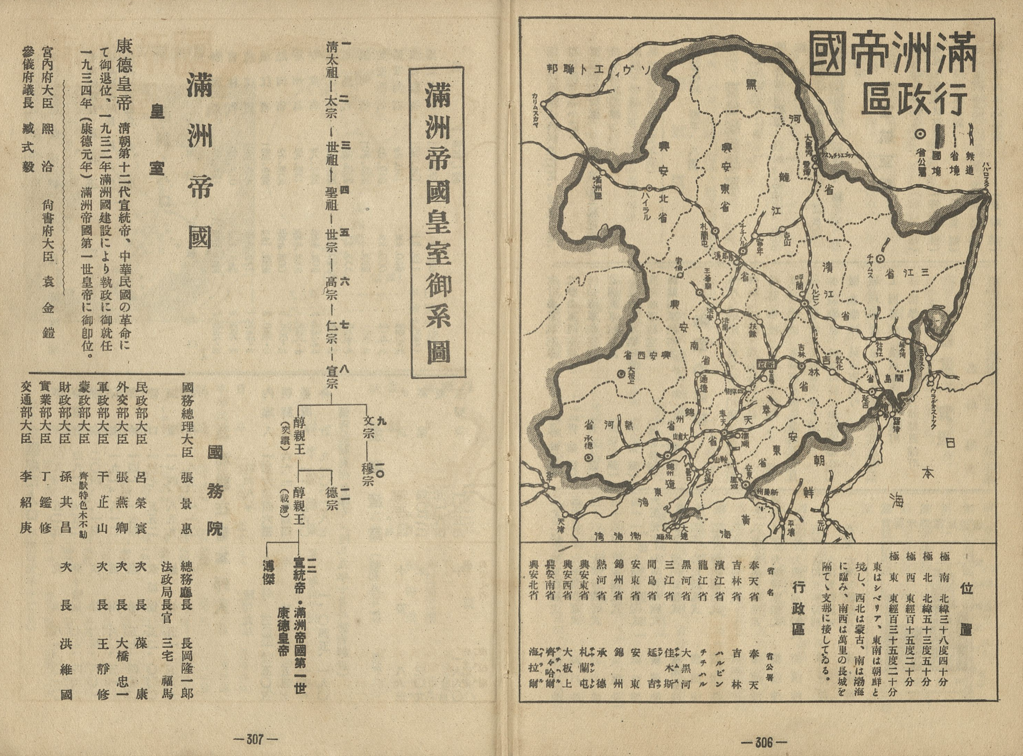
The map mixes two ways of reckoning the year, one each for events prior to the beginning of the Shōwa era in 1925 and the other for those after. Thus, we see various occupations of Manchurian sites listed in both the Japanese imperial year (皇紀 kōki) dated from the legendary founding of Japan and the Japanese era year (年号, nengō). The occupation of Mukden (奉天, Fengtian, Hōten, now Shenyang) during the Russo-Japanese war is depicted for year 2565 (1905), and the founding of Manchukuo (満洲国, Manzhouguo, Manshūkoku) as Shōwa 7 (1932). Here, central China gets none of its own history depicted – though they do get a few in a later map of world events, and instead three events related to Japan’s brief 1932 attack on Shanghai are shown.
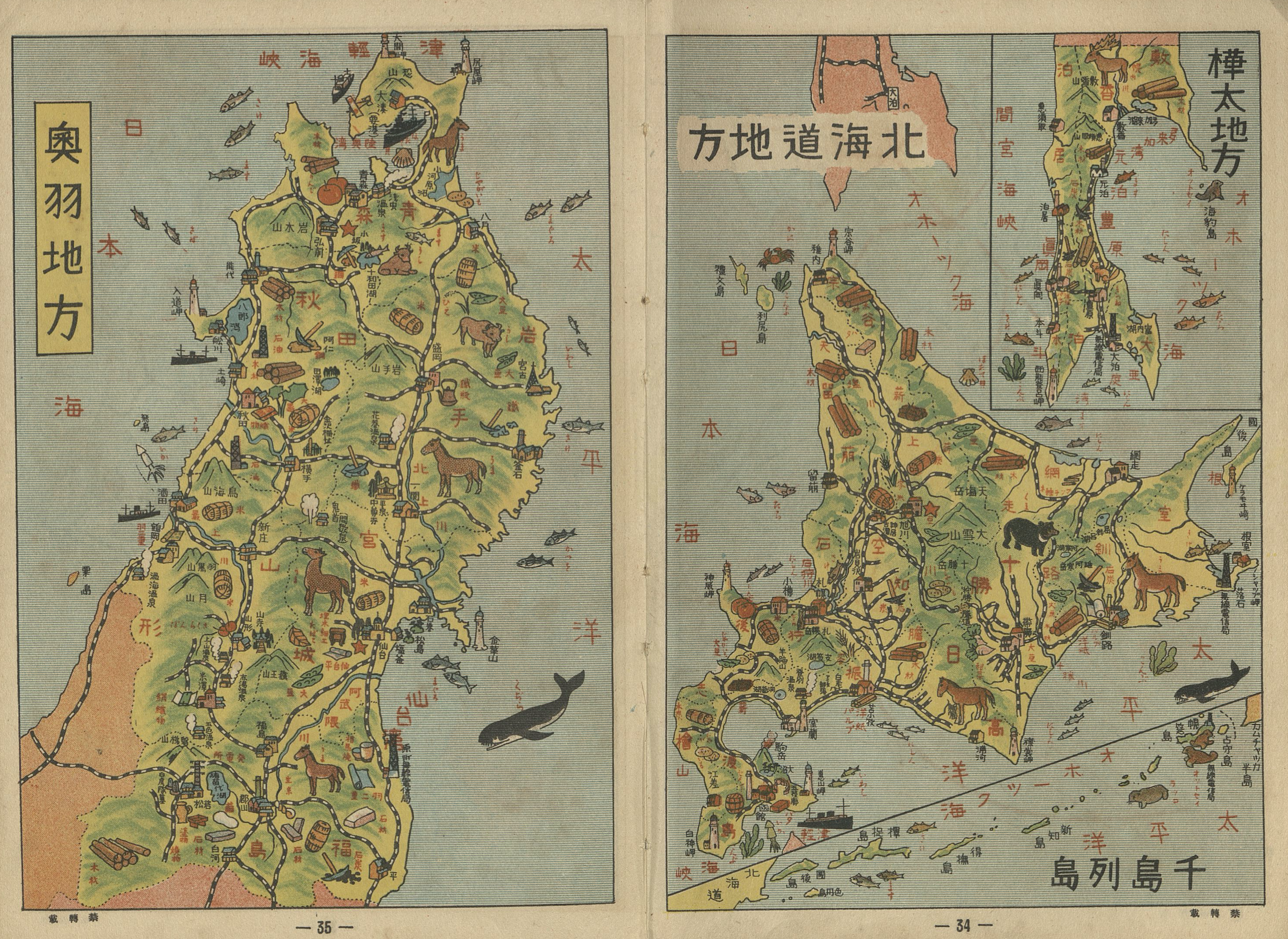
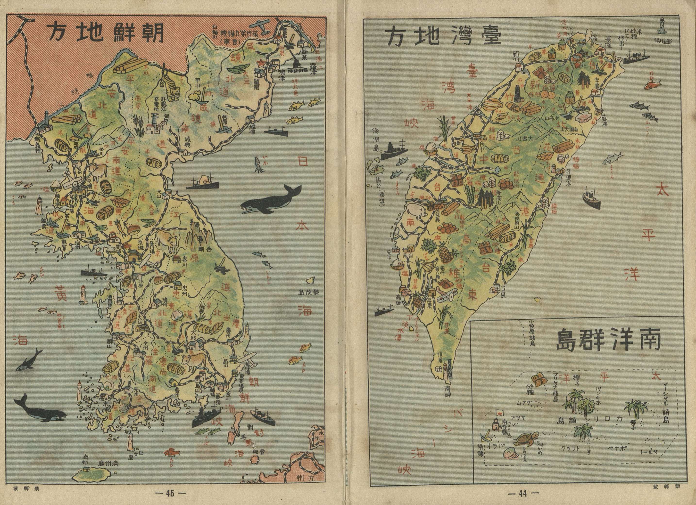
Through a similar form of selective representation a child can browse more detailed maps of each part of Japan, including its colonies, where icons for major resources and industries are shown. Whales, ships, and random airplanes dot the seas and land to complement the resources. Before moving onto maps of the continents, the map of the “empire” of Manchuria gets a full two pages, despite the fact this is not a “region” of Japan.
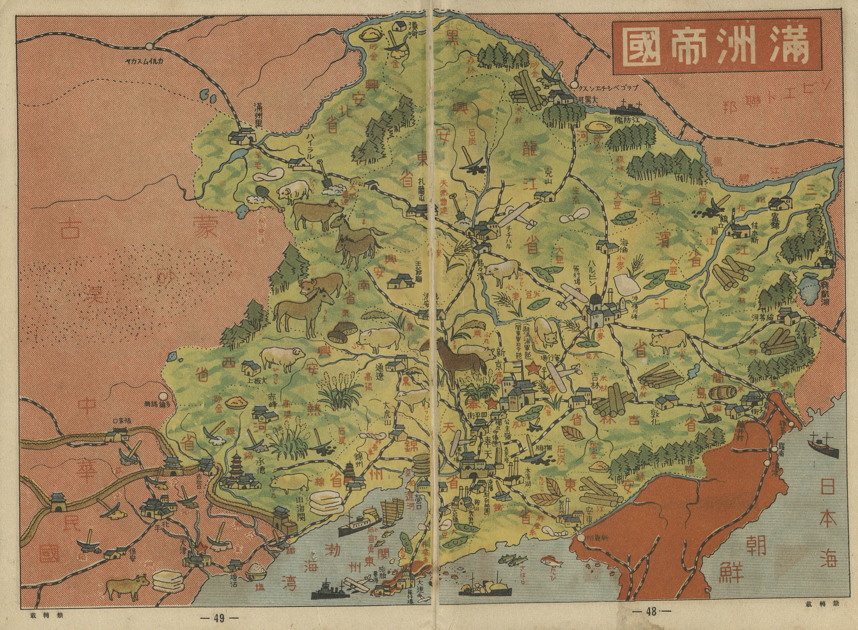
Japanese Dairen/Dalian and the Korean peninsula are seen in red at the bottom, while the larger two page spread for the map helps reinforce the (false) impression of Manchuria as a vast and, compared to the maps of other areas, more empty space.
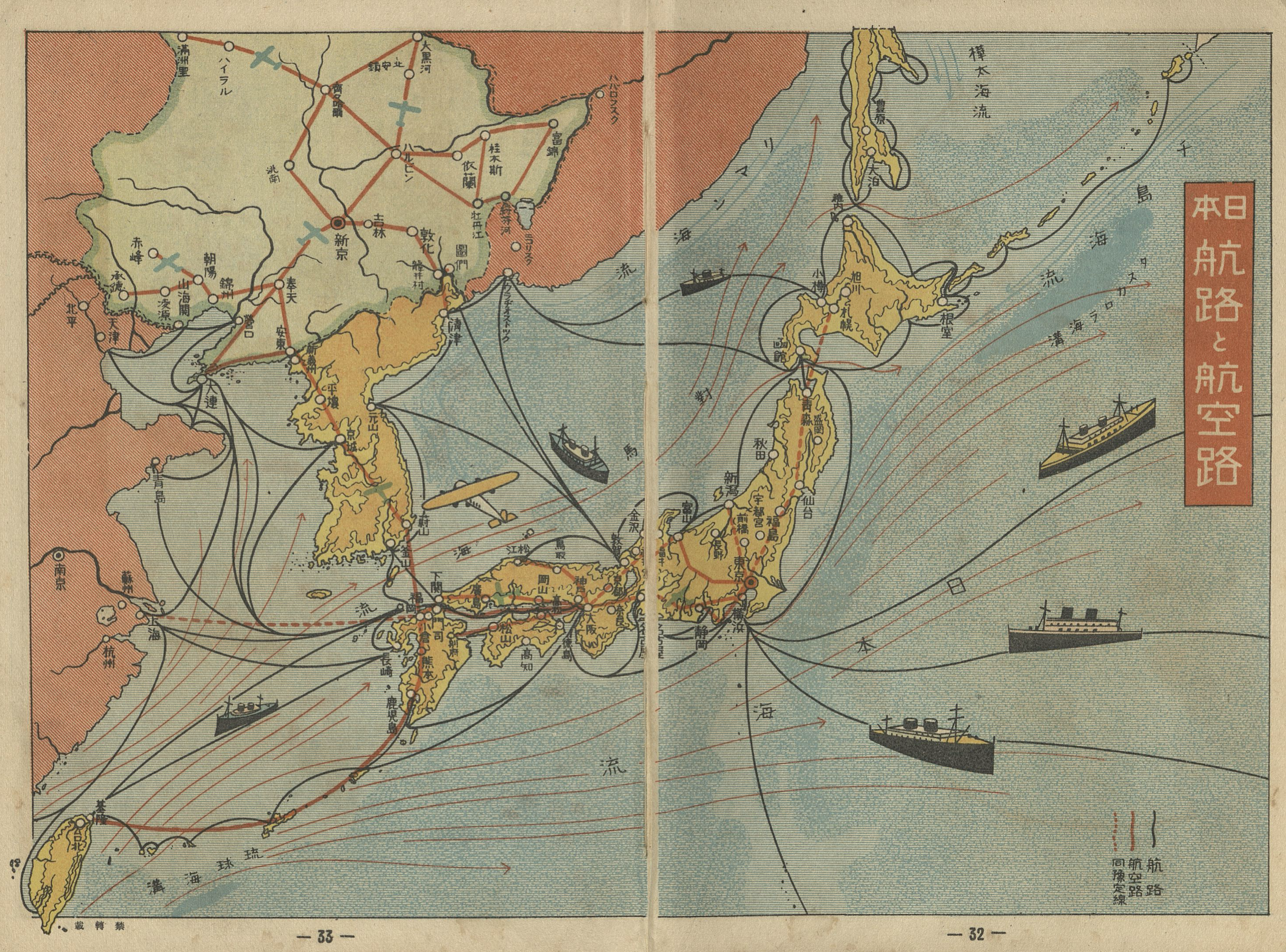
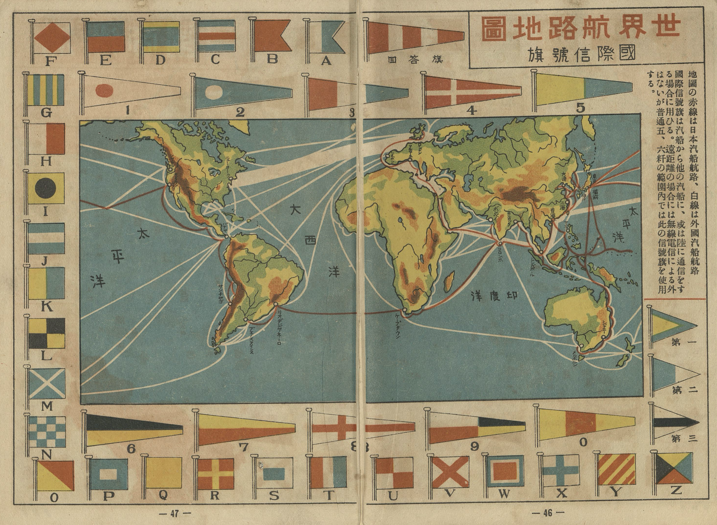
Maps are also included that explore the transportation networks by sea and air, both within the empire and its Manchurian client state, but also globally. The world map, somewhat poorly drawn, places Europe in the center, rather than Asia in the center as seen in some maps. Routes are divided into white, for “foreign” lines, and red lines for Japanese routes.
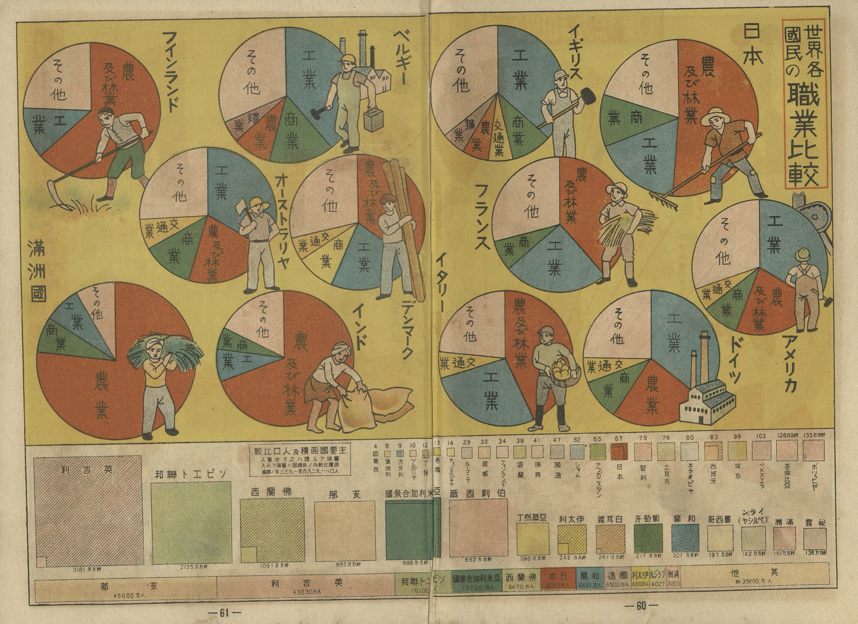
After exploring Japan and the world in terms of its products and famous places, there are over 20 pages of comparative statistics visualized. One of the visual techniques for visualizing statistics very widely used around this period and well into the postwar period is the use of the size of images to depict larger or smaller numbers: populations depicted with larger or smaller human figures on a map, for example, but other examples await us below. They also make frequent use of decorative images around pie charts and other graphs which are no doubt appreciated by a child less interested in the numbers, such as the 1934 import and exports of the country presented in pie charts. One information packed pair of pages compares countries by the distribution of labor forces in various countries. Japan is shown with just over half of its labor force in agriculture is next to Britain with industry and “other” making up about two thirds of the whole. France, the United States, Germany, Italy, Belgium are listed, which we might expect, but the pages also include India, Austrlia, Manchuria, Denmark, and Finland. The Soviet Union and China are not included, we might note, though both feature in the statistics visualised along the bottom where area and population are compared and the world’s overall population proportions are shown.

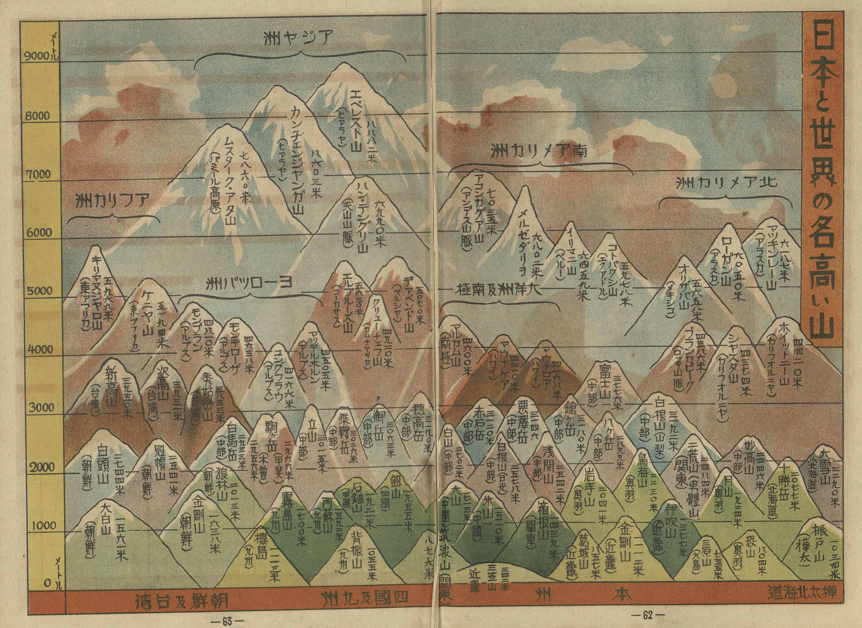
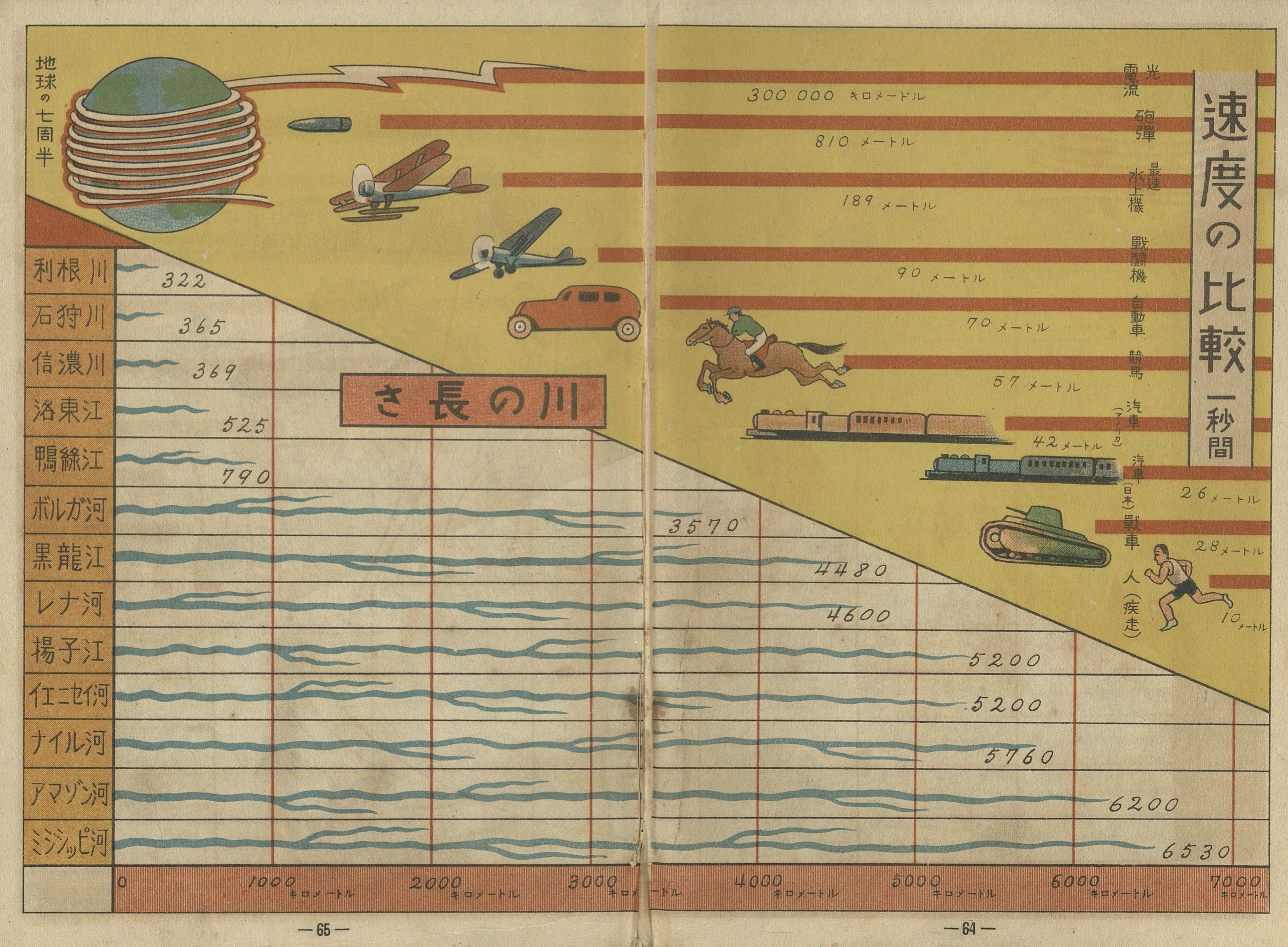
Other comparative maps follow. One map compares the highest mountains of the world, and another compares the length of Tokyo station with the height of various skyscrapers, towers, and other buildings. Another is split between a comparison of how far different things can move in a single second, from a slow 10m per second for a human, to 810m for a bullet and 300,000km for the speed of light, with a separate graph comparing the length of rivers. Another double page visualisation compares the distances that various modes of transportation can go, beginning in Tokyo. A human goes a leisurely four kilometers or 16.7km, arriving in Kawasaki if running the entire way. A Japanese train can go 95km, and speedy German train 150km. This is still slower than a (regular?) car listed with a top speed of 251km per hour (?!).

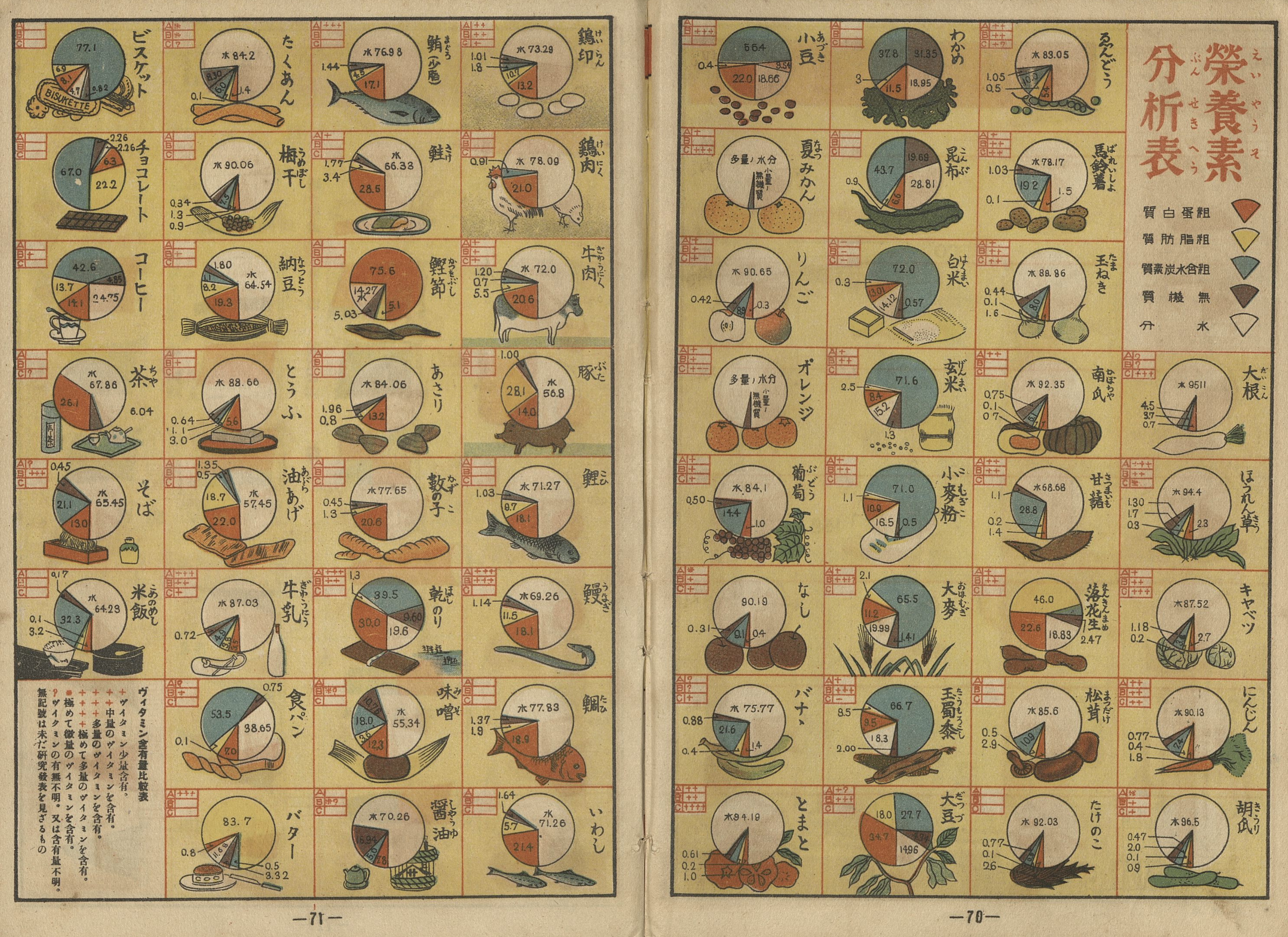
One of the most eye-catching of the comparative charts is that related to nutrition. The water (white), mineral (brown), carbohydrate (blue), fat (yellow), and protein (red) content of various foods are presented from a range of foods from chocolate (チョコレート) to butter (バター) and from soybeans (大豆) to milk (牛乳). There are some surprises. Coffee (コーヒー) is listed as 42.6% carbohydrate and 13.7% fat, which I assume means that milk and sugar were included in generous amounts.
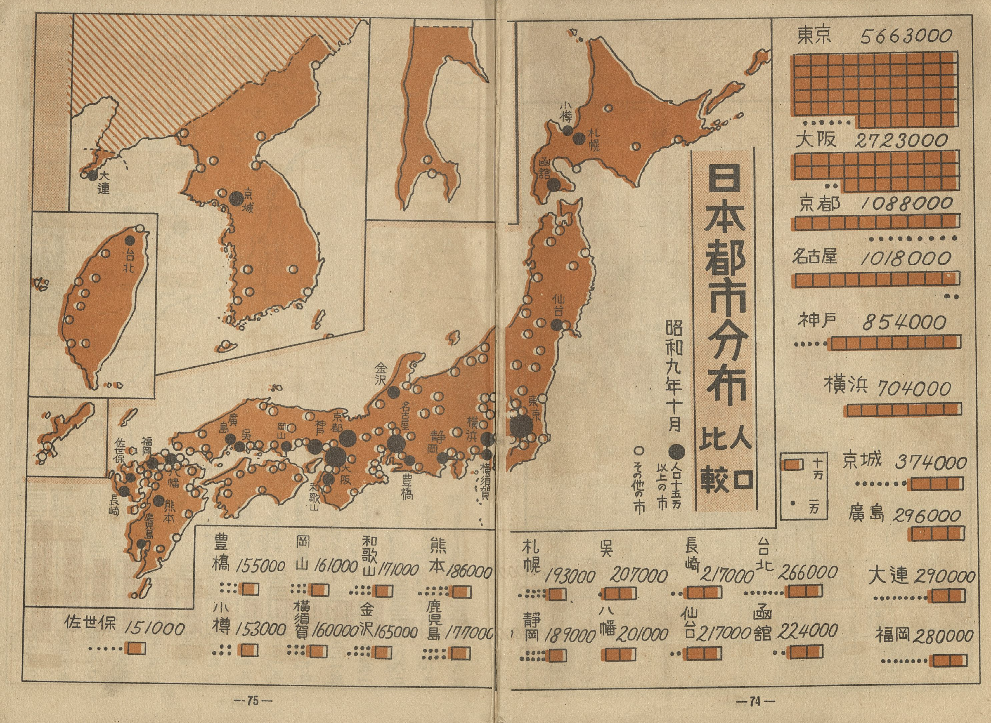
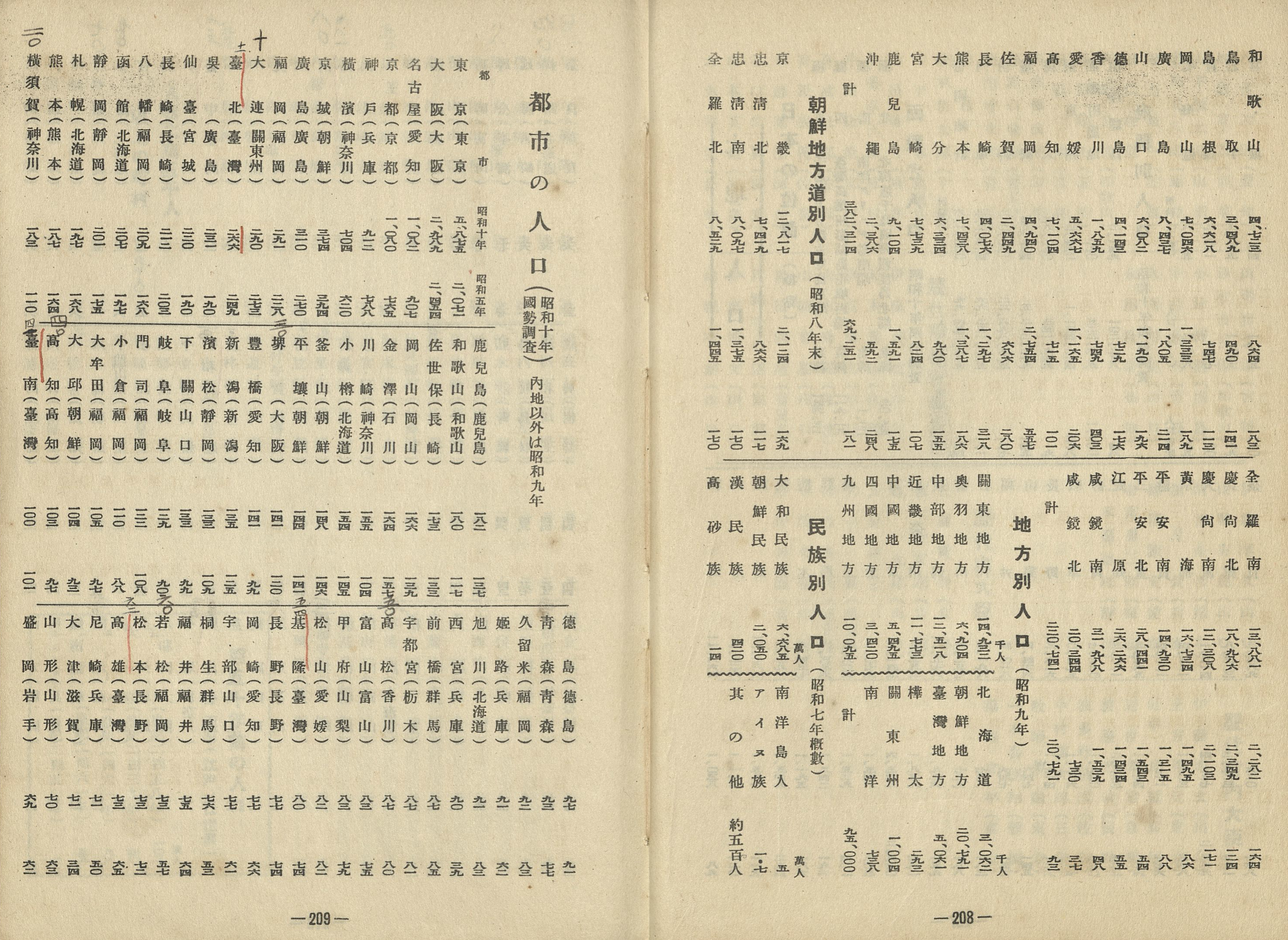
A graduated symbol map comparing the population of Japanese cities as of October, 1934 notes that Seoul (京城 Keijō) is the 7th largest city of the empire (claimed to be a population of 374,000), Dairen (Dalian) in 9th with 290,000, and Taipei (台北 Taihoku) in 11th place claimed to have a population of 266,000. Tokyo, with over five million is depicted on the following map as the second largest city in the world behind New York with 6.9 million and ahead of London with a claimed 4.4 million (both of these seem to be an undercount).
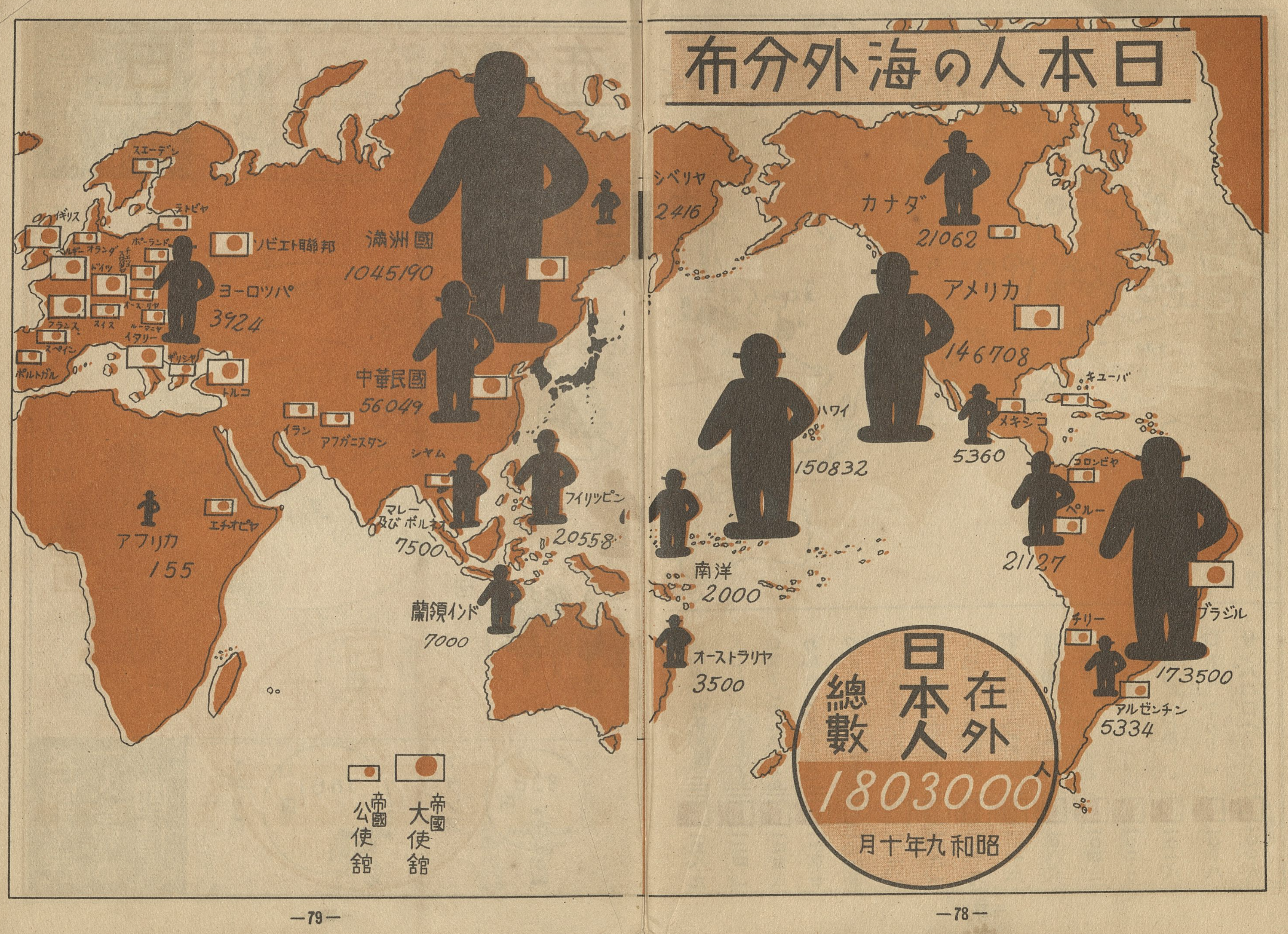
Another important population map depicts the distribution of Japanese outside of Japan, depicted by large black bowler hat wearing figures planted in various places, as well as the location of embassies and consulates. The child will notice the large number of Japanese in Brazil (173,500), in Hawaii (150,832), the rest of the US (146,708), Manchuria (over one million), and China (56,049) as well as over twenty thousand Japanese in the Philippines, then under American imperial rule.
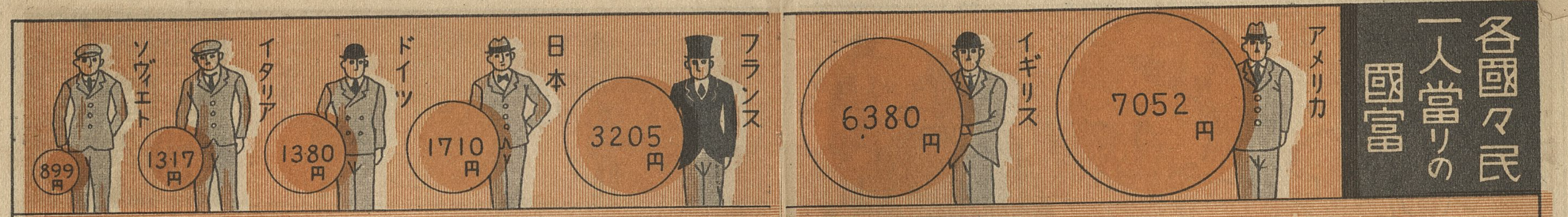
Relative economic wealth is shown, including a depiction of the per capita wealth of Americans (7052 yen), British (6380 yen), French (3205 yen), Japanese (1710), Germans (1380 yen), Italians (1317 yen) and Soviets (899 yen). A separate chart shows the per capita income of the British (1412 yen), Americans (1251 yen), French (688 yen), Germans (601 yen), Soviets (509 yen), and the Japanese (165 yen). Other comparisons such as national bonds, per capita postal savings, and others. For example, the child will learn that for every car there are only five Americans, but 725 Japanese, and that when it comes to military expenditures, Japan is third (9.4m yen) behind Britain (10m yen) and the United States (14m yen), but well ahead the reported spending of Germany at 3.2m yen).

What I have shown above are some of the books most visually rich pages, but the more text heavy pages from around p89 to p390 are filled with reference information of every sort. They include a list of important laws and imperial edicts. It even includes Japan’s imperial edict withdrawing from the League of Nations. It includes the text of the Meiji constitution, famous poems, timelines, imperial genealogies, lists of important shrines and temples, government cabinet members, key statistics on population and area, and the list of populations of cities throughout the empire. Note that the young Dr Hung, or someone else he lent the book to, has underlined most of the Taiwanese cities such as Taipei (台北 Taihoku, Taibei) Keelong (基隆 Kiirun, Jilong), Kaohsiung (高雄 Takao, Gaoxiong) and many others, and offered some corrections to the numbers.

There are detailed trade statistics for locations within Japan and abroad. There is a geographical section with prefecture by prefecture information on cities, transportation, famous products, ruins, and even military installations. Similar tables are available for countries throughout the world. One page offers a map of the world’s “economic blocks” including a Japan-Manchuria block, the British imperial block, the French imperial block, the American block, and the Soviet block. The description below the map an explanation claims that the great powers are following a policy of being self-sufficient within their own area of control, raising tariffs and obstacles to trade and preventing foreign imports. “That is to say, even if a war were to break out, each block (unit) would be able to meet its needs for products from within.”

There are climate tables. There are lists of the important train lines and tables for the 1934 levels of production of certain agricultural or mineral commodities. There are military charts, including lists of ships in the navy of various kinds. There is a kind of biographical dictionary of important personages from Hitler to Gandhi. There is a list of common new words, including some easy loanwords like アイロニー (irony), スランプ (slump), but also more puzzling ones like エックス (ekkusu, defined as 疑問、未知の事物 doubt, unknown thing)4, and unexpected definitions such as that for ウラー (uraa, as in hurrah! Defined as ロシア語の万歳, Banzai in Russian. Apparently the Russian ура).
There is a separate section for Manchuria which offers an administrative map, the genealogy of its imperial family, as well as a range of statistics on the population, economy, education, trains, foreign investment, together with a very short list of countries that have recognized the new country, or at least have a postal agreement in place.
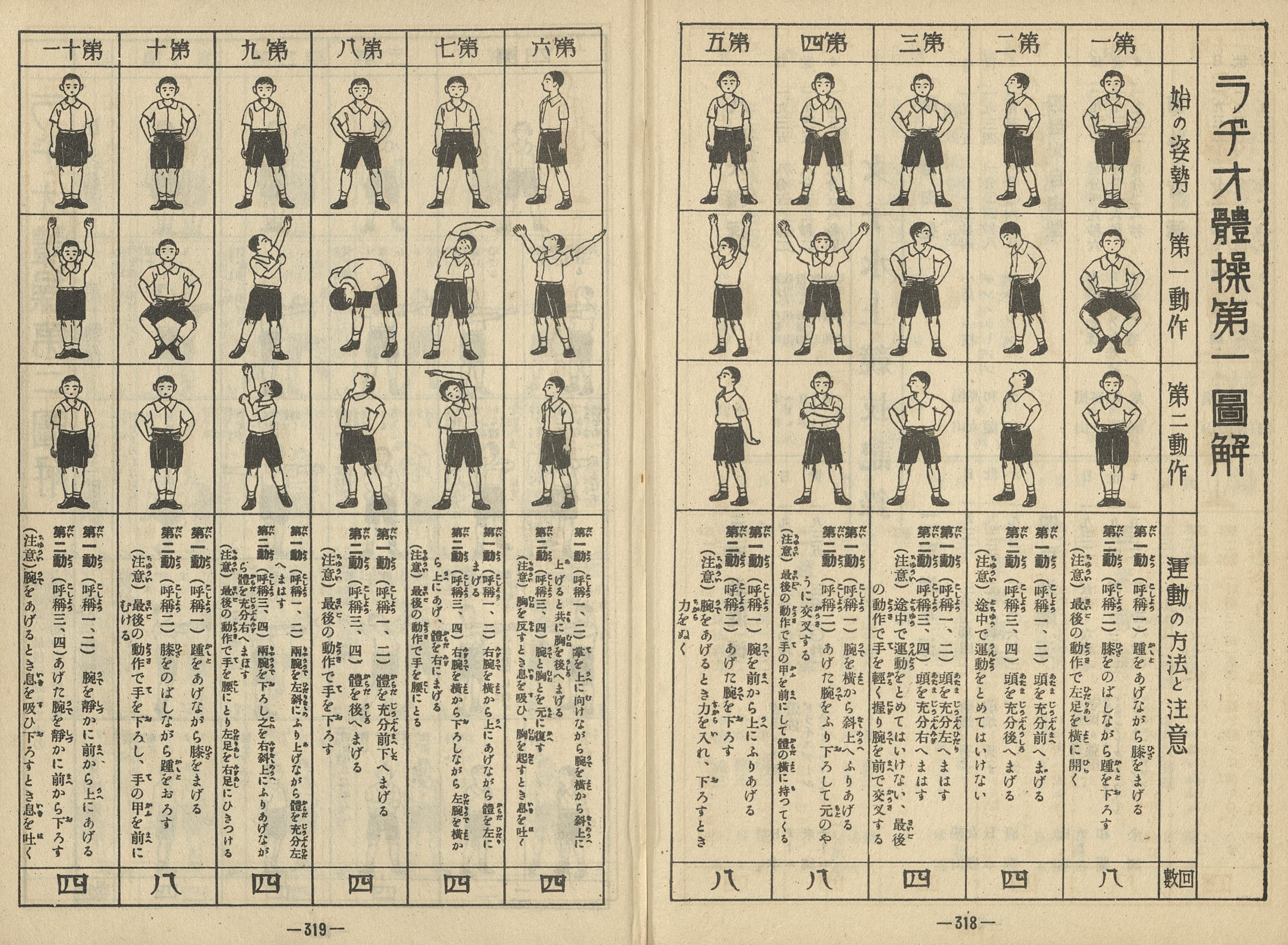
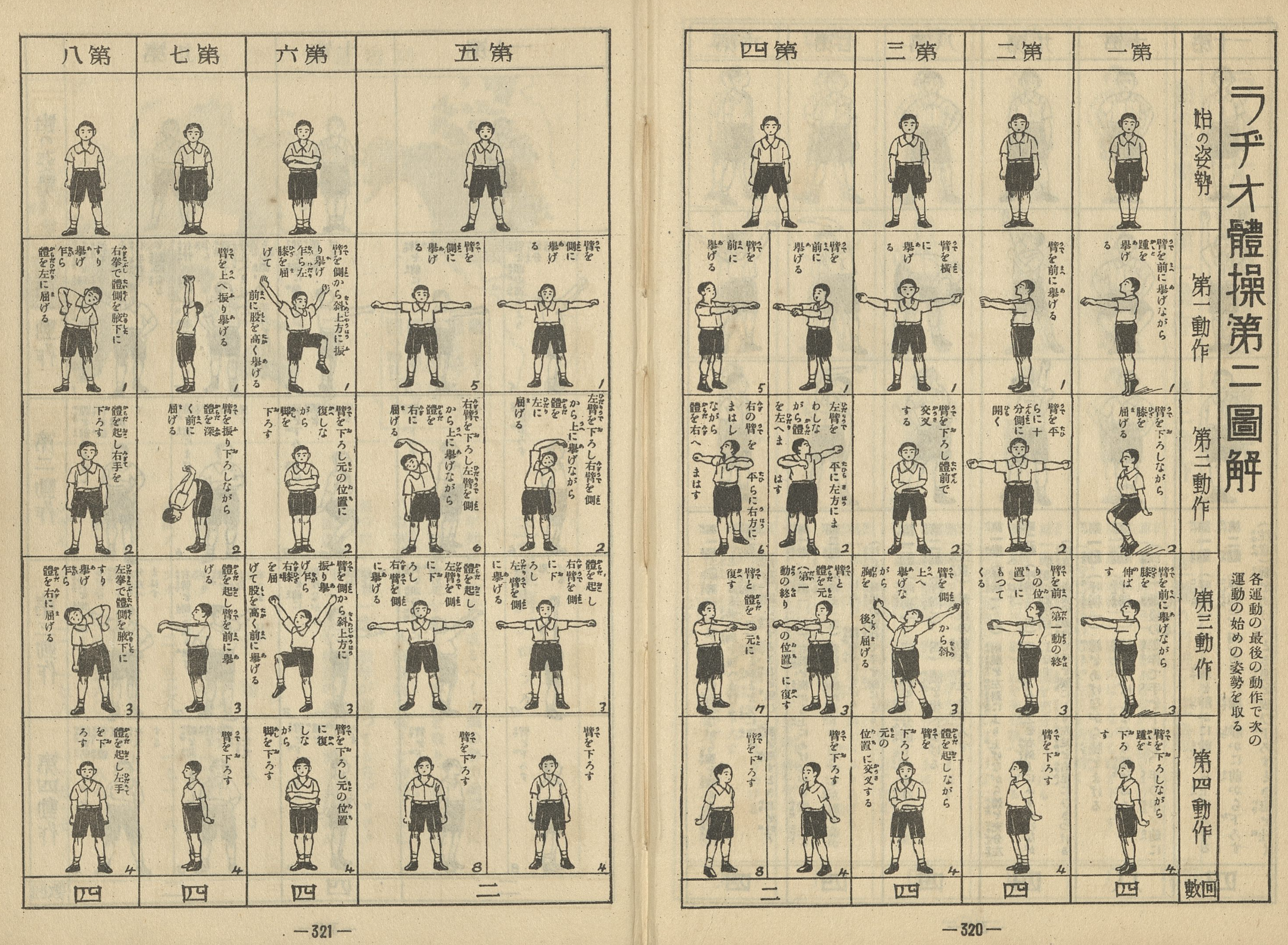
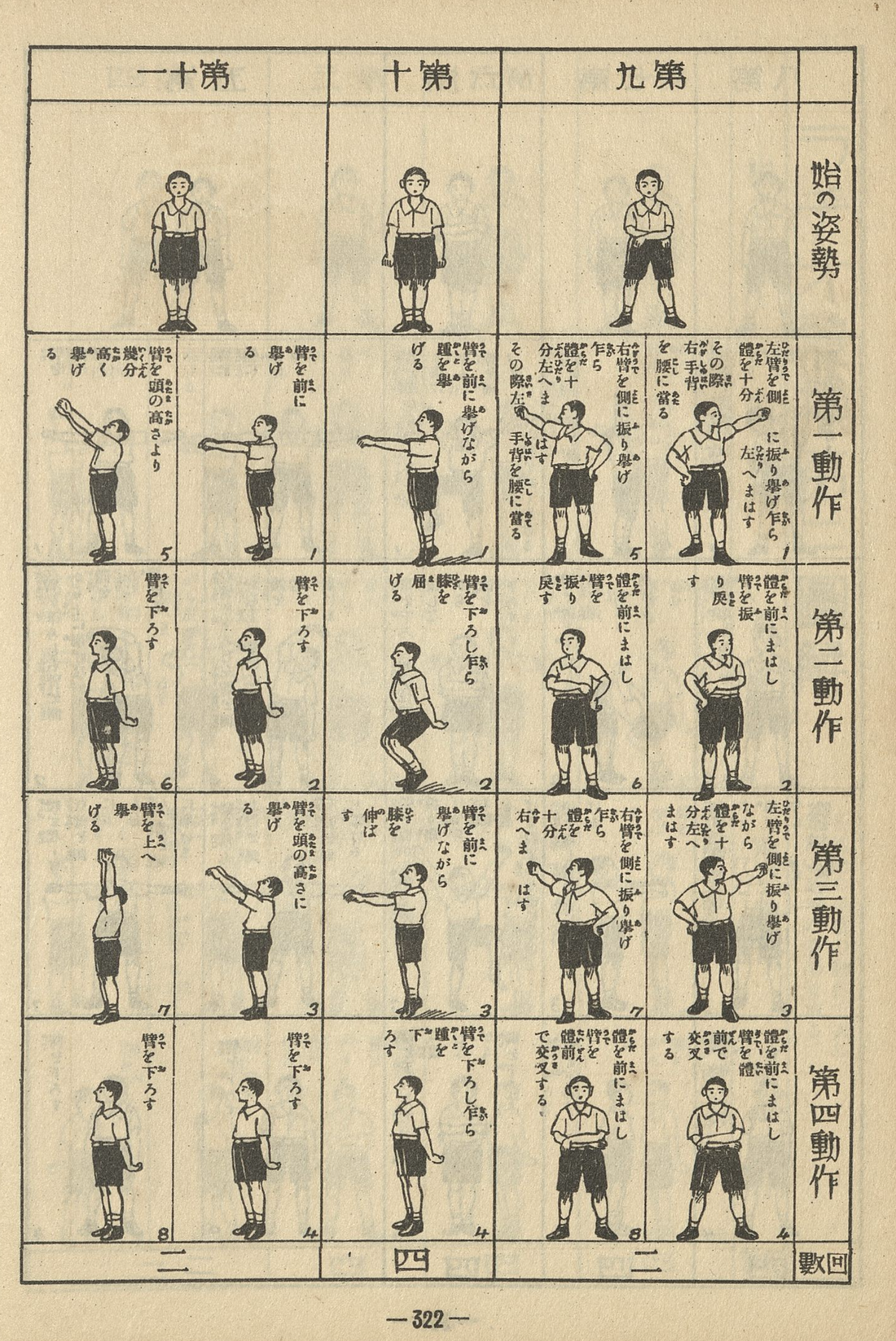
There are sports statistics, showing, for example, the fastest running times at various distances with the Japanese, world, and Olympic records printed with sections for both men and women. The sports section is followed by instructions for the all important radio calisthenics (ラジオ体操 rajio taisō) still performed by school children and many adults today.
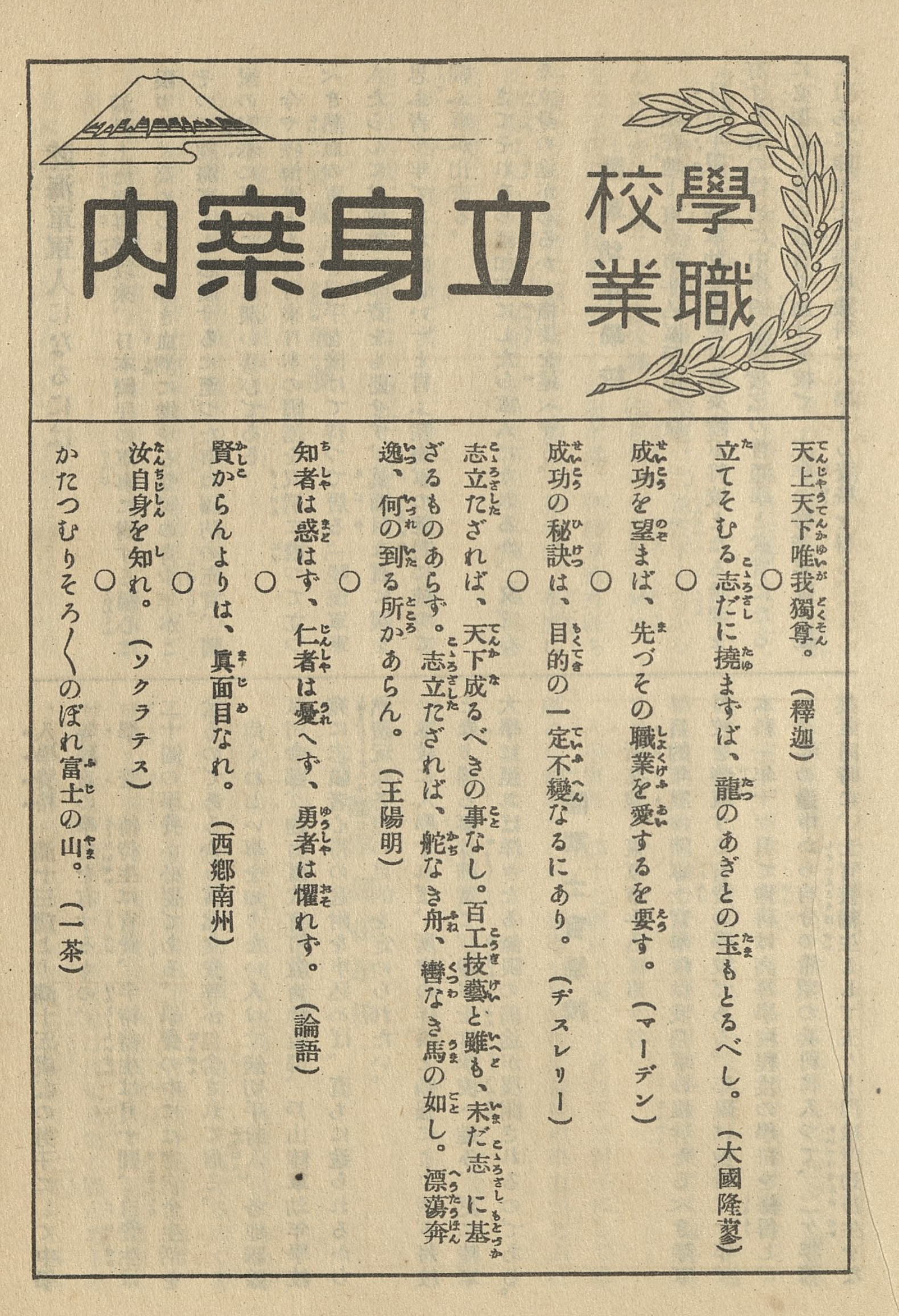
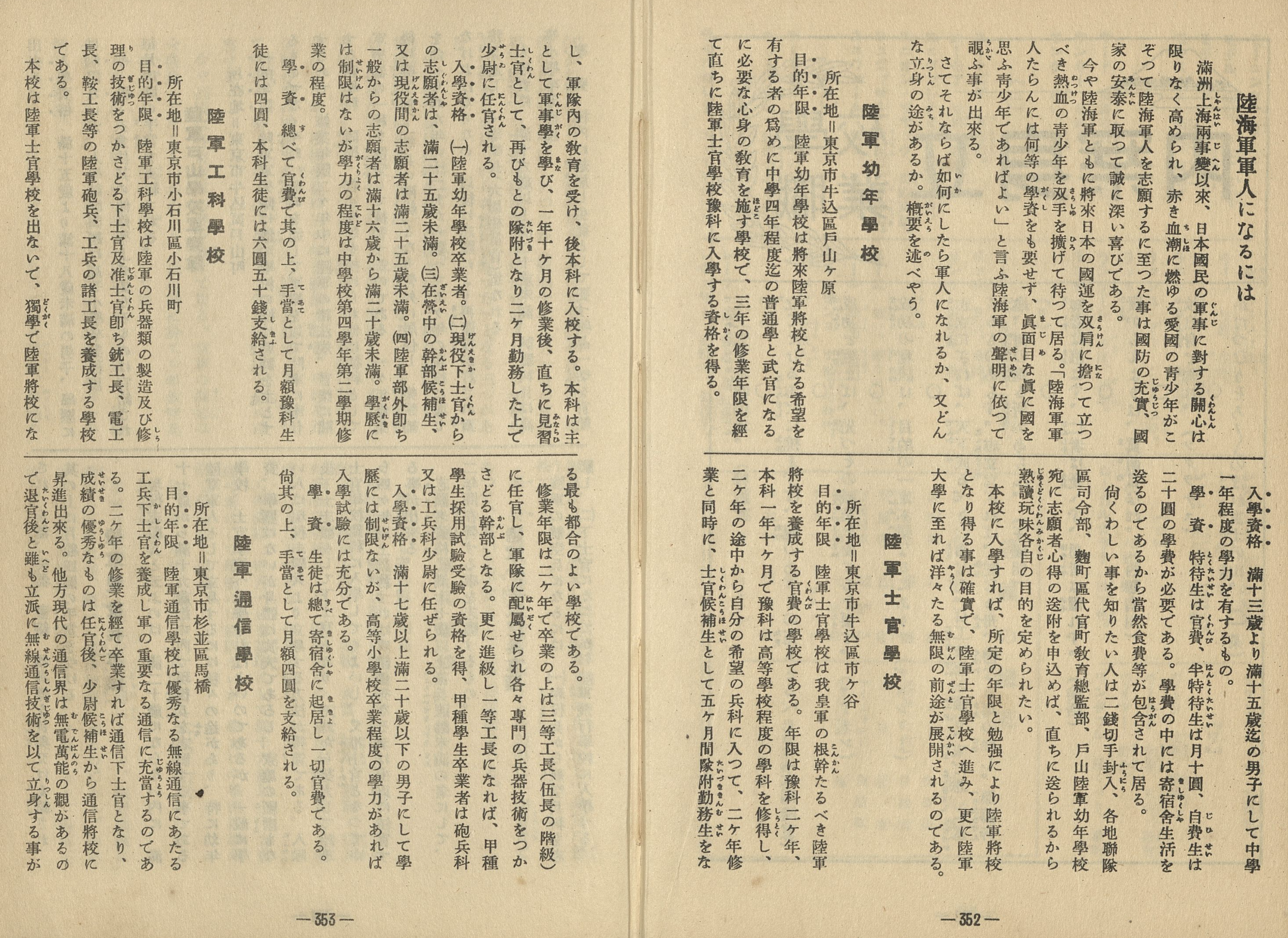
Another fascinating section of this text is the 学校職業立身案内 section, a sort of guide to how to achieve the career of your dreams. After opening with some classic words of inspiration from sources such as the Confucian analects, Wang Yangming, Socrates, and Benjamin Disraeli, this section of the book offers career by career breakdown of a child needs to do beginning, of course, with seven pages on a full range of military careers. Then there are tips for one aiming for a career as a bureaucrat, a doctor, a bank employee, an author, a painter, a teacher, a musician, a train employee, an elementary school teacher in Manchuria, a wireless technician, a typist, a telephone operator, a dressmaker, and finally a beauty salon employee. The very list of careers itself seems to embed a normative order for social occupation and gender.
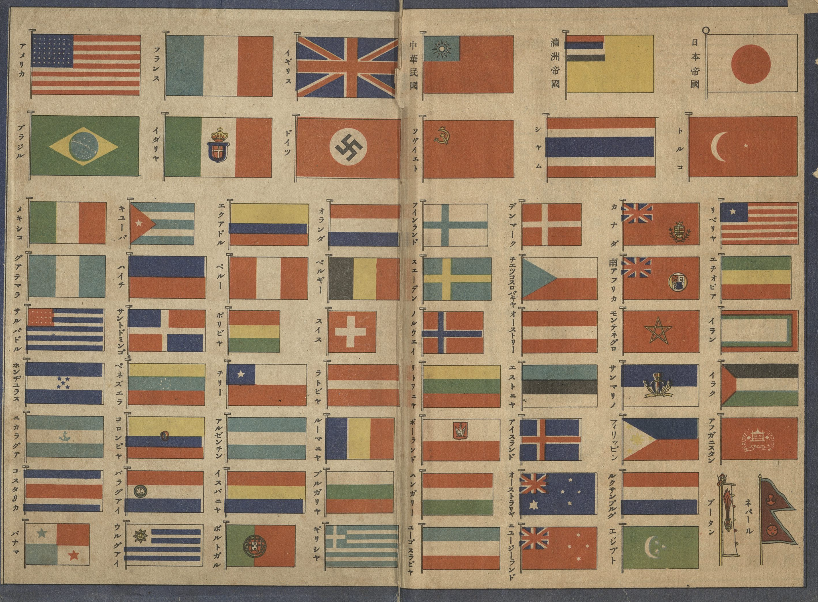
The book’s final pages are dedicated to some language reference tables and concludes with a list of flags and an advertisement for some of the other yearbooks/almanacs available from the publisher.
Gakuyū Nenkan is a children’s reference book for an increasingly expansionist Japanese empire, but it is by no means a unique text. Almanacs, gazettes, and encyclopedias packed with reference information could be found around the world on the shelves of children and adults in this period and since. Looking at an old copy of Pears’ Cyclopaedia from 1939 I picked up on ebay some years ago, I was struck by some of the similarities. The Pears’ books are more broadly aimed for a wider audience mostly of adults, but were no doubt useful to young students as well.
In my edition, published only a few years after the text we have been looking at I was struck by the flags of the world listed, with a full page dedicated to the flags of British empire.

Like Gakuyū Nenkan, we see that the book, over the course of its regularly updated editions has grown to incorporate a mish mash of different kinds of reference information. “Sixteen complete works of reference” are included in “one Handy Volume of 864 Pages.”

Pears’ Cyclopaedia too offered a “Students’ Compendium”, though it was far shorter than the several hundred pages of student targeted reference information we have been considering. A laughably short “historical dates” on the opening page offers only a minimalist list of historical events for a young British student to memorize: the Crimean War, the Gunpowder Plot, the Indian Mutiny, the Magna Carta, the Peace Treaty at Versailles, Trafalgar 1805, the Transvaal War, the outbreak of war with Germany on September 3, 1939, and the Battle of Waterloo. The “useful information” section, some few dozen lines, seems particularly arbitrary, and includes random facts one after the other beginning with the size of a badminton court, followed by the size of a battallion, and the price of a driving license.
The section that immediately follows it, however, mirrors that of our Japanese text: Careers. The careers section, like its Japanese counterpart, offers instruction to the young British child on how to aim for a career of their dreams. Like our Japanese text, it begins with military careers: Navy, Army, and Royal Air Force. Like our Japanese text, next up is the Civil Service, with subsections for Colonial Police, West Indian Constabulary, East and West African Police Forces, and so on. Here the two diverge, with the Japanese text listing doctors next, while the British reference work moves on to accountants. While the Japanese text at least included some career options that explicitly mention women, nothing of the sort in this Cyclopaedia, which moves directly on to its table of Latin and French verbs.


As with many such texts, their highly condensed nature, much like its maps showing historical events or local products, force its editors to make stark visible choices about what is in and what is out, what comes first and what comes last. For this reason and many more, they can be wonderful windows into the priorities of an age.
See more images and comments supplementing the book on this collection of youtube vidoes. ↩
This is just one of now hundreds of textbooks and educational materials from Japan’s modern history that can be found in digital form. A great starting place to look for these materials is the Hiroshima University library’s textbook collection: 教科書コレクション画像デーだベース ↩
See Paul D. Barclay’s open access Outcasts of Empire: Japan’s Rule on Taiwan’s “Savage Border” 1874-1945 ↩
Update: Thanks to Michael Cannings, @formosaphile, who points out this probably is “x” as in the uknown factor in a mathematical equation. It would be interesting to see if it jumped math and made it into other conversational contexts. ↩
Thank you Konrad! Appreciate it! From uploading to archive.com to writing this excellent post! It is wonderful.
Fascinating find and an exhaustive overview! And the comparison with Japan’s imperial ideal of the time, the British Empire, is very pertinent.
Just to add that the illustrations interestingly display the global naval dogma of the time, the primacy of large surface warships as per Mahan’s battleship doctrine. All the naval units pictured are cruisers and battleships, not even one aircraft carrier. This despite the fact that the IJN at the time was the world leader in carrier operations, which of course would quickly prove the battleship doctrine obsolete mere years later. So, even in 1936 Japan, the battleship was perceived to be king.
Thank you Professor Lawson. The Manchuria maps certainly reflect the mid-1930s vintage of this publication. The large 忠霊塔 (Towers to Loyal Spirits) that began construction in 1934 and became staples of Manchukuo iconography by the late 1930s have yet to appear. And extra thanks for catching the Wushe icon and caption–of all the the things to commemorate in Taiwan, certainly an interesting choice (Kitashirakawa not so surprising).
“That is to say, even if a war were to break out, each block (unit) would be able to meet its needs for products from within.”
It’s interesting to see how open they were about their designs on empire.